About Cal Traffic
Cal Traffic (caltraffic.com) is a free viewer for California’s public Caltrans traffic cameras. It shows more than 3,000 live Caltrans highway cameras, still images and live video, across all 12 Caltrans districts, with CHP incidents, lane closures, chain controls and weather alerts. You can browse cameras by highway, region or city, see every camera along a drive with the route planner, and build your own multi-camera view. It is an independent site and is not run by or affiliated with Caltrans or CHP.
Data Sources
All data is public domain, sourced from California state agencies and open services.
| Source | Provides | Refresh |
|---|---|---|
| Caltrans CWWP2 | 3,000+ cameras, CMS signs, chain controls, lane closures, RWIS weather, travel times | 30-120s |
| CHP Incidents | Real-time traffic incidents statewide | 60s |
| National Weather Service | Active weather alerts for California | 5 min |
| OSRM | Route geometry and turn-by-turn directions | On demand |
| Photon / Nominatim | Address and city geocoding | On demand |
Caltrans District Map
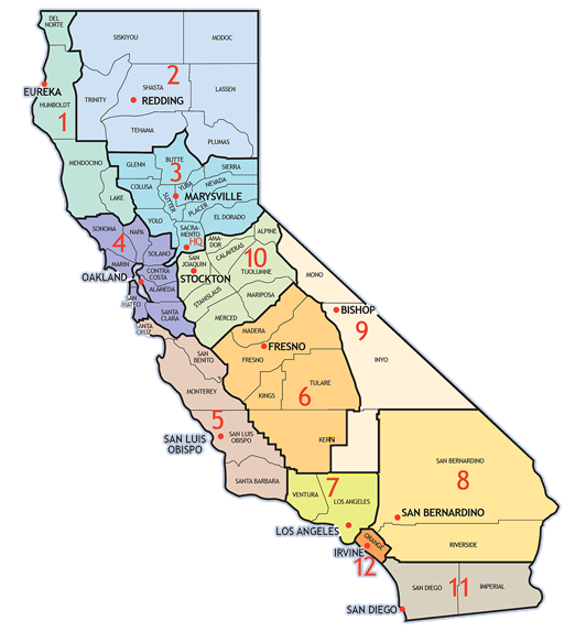
D01 — Eureka / North Coast
D02 — Redding / Northeastern CA
D03 — Sacramento / North Central
D04 — Oakland / Bay Area
D05 — San Luis Obispo / Central Coast
D06 — Fresno / Central Valley South
D07 — Los Angeles / LA Metro
D08 — San Bernardino / Inland Empire
D09 — Bishop / Eastern Sierra
D10 — Stockton / Central Valley North
D11 — San Diego / Border Region
D12 — Irvine / Orange County
District Capability Matrix
Not all data sources are available in every district. This is a Caltrans limitation, not an app limitation.
| District | Cameras | Signs | Chains | Closures | Weather | Travel | Live Video |
|---|---|---|---|---|---|---|---|
| D01 — Eureka | Y | Y | Y | Y | - | - | Y |
| D02 — Redding | Y | Y | Y | Y | Y | - | Y |
| D03 — Sacramento | Y | Y | Y | Y | Y | Y | Y |
| D04 — Bay Area | Y | Y | Y | Y | - | - | Y |
| D05 — SLO | Y | Y | Y | Y | - | - | Y |
| D06 — Fresno | Y | Y | Y | Y | Y | - | Y |
| D07 — Los Angeles | Y | Y | Y | Y | - | - | Photo |
| D08 — Inland Empire | Y | Y | Y | Y | Y | Y | Photo |
| D09 — Bishop | Y | Y | Y | Y | Y | - | Photo |
| D10 — Stockton | Y | Y | Y | Y | Y | - | Photo |
| D11 — San Diego | Y | Y | Y | Y | - | Y | Photo |
| D12 — Orange County | Y | Y | Y | Y | - | Y | Photo |
How the Cameras Work
Camera feeds come from the Caltrans Commercial Wholesale Web Portal (CWWP2), which aggregates traffic cameras from all 12 Caltrans districts.
Still images vs. live video
Most cameras provide static snapshots that update every 1–5 minutes depending on the district. Approximately 1,800 cameras also support real-time video streams — these are shown with a live video badge and play directly in the viewer.
What "Stale" means
A camera is marked stale when its image hasn't updated in 15 or more minutes. This usually means the camera is offline, under maintenance, or experiencing a network issue on Caltrans's end. It is not an app error.
Camera quality
Camera quality varies widely across the state. Newer installations are HD (1080p or better); many older units are low-resolution NTSC cameras from the early 2000s. Caltrans is gradually upgrading the fleet but the rollout is ongoing.
Chain Control Levels
Chain controls are issued by Caltrans field crews for mountain passes and winter routes. The three levels indicate increasing severity:
Chains or snow tires required on drive wheels. Vehicles with all-wheel drive and adequate tread may be exempt depending on conditions.
Chains required on all vehicles, no exceptions. Snow tires and AWD are not sufficient — physical chains must be installed on drive wheels.
Highway closed to all traffic. The road is impassable and no vehicles are permitted through, including commercial trucks and emergency-equipped vehicles.
Data Freshness
All data is public and freely available from California state agencies and federal services. Here's how often each source updates:
| Data Type | Source | Update Frequency |
|---|---|---|
| Camera stills | Caltrans CWWP2 | Near real-time (1–5 min lag) |
| Live video | Caltrans CWWP2 | Real-time stream |
| Incident reports | CHP CAD system | Updated as dispatchers log events (~60s) |
| Chain controls | Caltrans field crews | Updated manually as conditions change |
| Lane closures | Caltrans CWWP2 | Updated as work zones open/close |
| Weather alerts | National Weather Service API | Updated as conditions change (~5 min) |
Support This Project
If you find this tool useful, consider supporting its development. Every bit helps keep the servers running and the data flowing.